Galileo, the European satellite navigation system, provides greater accuracy in determining time and position than GPS by making use of the latest technologies and signals. Positions can be determined to an accuracy of within one metre. Every point on the Earth’s surface is covered by at least four and at most eight satellites. This civilian navigation system is available for governmental authorities, companies and the general public. It provides better support for the vital infrastructure in the Netherlands. In addition, it provides opportunities for unmanned systems such as autonomous driving, sailing and flying using e.g. drones.
Hein Zelle and Judith van Bruggen are R&D engineers at Royal NLR and they are closely involved in the research and activities relating to satellite navigation and Galileo. “NLR has a rich history of accumulating knowledge relating to satellite navigation,” says Van Bruggen. “NLR has been involved in the development of GPS, EGNOS – an additional navigation system for aviation – and then in Galileo. Now that the Galileo system is coming online, the focus is shifting from development to testing, verification and monitoring. NLR is studying the risks, vulnerabilities and performance of receivers, as well as detecting interference. What are the properties of such interference and how can it be counteracted? What special antenna technology or what special algorithms must be used in the receivers for detecting and filtering out interference? NLR has an understanding of the Galileo system, the signals and navigation messages, the ground-based systems and the typical characteristics of interfering signals.”


NLR provides assistance and advice for the Ministry of Infrastructure and Water Management, the Ministry of Defence, the police, the Directorate-General for Public Works and Water Management, Air Traffic Control the Netherlands (LVNL) and others about the use of GPS, EGNOS and Galileo. The purpose of this advice is protecting the vital infrastructure, for example when integrating GPS or Galileo into existing applications. A multidisciplinary approach is used for gathering knowledge and combining it from the various activities of the NLR and the initiatives in which it takes part. A few examples:
Galileo performance monitoring
The primary task of the Galileo Reference Centre (GRC) in the Netherlands is to monitor the performance of Galileo. Together with other parties in a consortium, Royal NLR supplies measurement data and performance calculations to the GRC. As part of the Netherlands’ contribution, NLR requests data from the Land Registry and processes it. The Land Registry has its own network of satellite receivers in the Netherlands in order to improve the accuracy of its surveying. Measurements are also made using the NLR’s Cessna Citation test aircraft.
Airfield monitoring
For the Dutch Air Traffic Control (LVNL), NLR measures the performance of GPS, EGNOS and Galileo at Dutch airfields. Based on these measurements, LVNL can introduce new approach routes and procedures based on GNSS; strict requirements have to be met for this. Approach routes based on GNSS provide major benefits such as more flexible routes, reduced fuel consumption and noise, and cost reductions for the infrastructure at the airfields.
Unmanned systems in aviation and the drone world
Tracking of unmanned systems, unmanned aircraft, cars and ships is widely used throughout the world. During autonomous flying, driving and sailing, the position is sent to a central system and monitored. NLR is investigating the vulnerabilities of receivers and how they can be improved, including creating an overview of the kinds of problems that arise in practice and recognising their characteristics. The key aspect here is detection.
Royal NLR knows a great deal about aviation and drone navigation, which are deemed to be part of the vital infrastructure. NLR also has specific expertise in antenna design, not only for use in aviation and the drone world but also in space. Antennas are capable of removing many distortions from the airwaves before the signals are actually processed.
U-Space satellite navigation for drones
U-Space is part of the European SESAR programme, an initiative that ensures efficient, safe and secure drone flying. It is anticipated that drones will be flown on a large scale in the future. Legislation and regulation need to be developed for professional drones in particular so that the enforcement authorities can monitor where drones are flying and whether drones are actually flying the route that was planned beforehand. Navigation plays a key role in this: how can you guarantee that the drone flies the route and what are you going to do if you detect it deviating from that route? In addition, strict requirements must be imposed to guarantee people’s safety, for example when the police fly drones above crowds of people.
What is Galileo?
Galileo is a global civilian satellite navigation system that is being developed by the European Space Agency (ESA) and the European Commission. It is the largest European space project ever. Galileo has been available for use since December 2016 and will become fully operational in 2020. The system is freely accessible for all. Galileo consists of 30 satellites (27 + 3 in reserve) that can independently provide more accurate information than the familiar GPS.
Click here for more information about Galileo
Joint Test Activities
In addition to the public signals, which anyone can receive, there are also secure signals. GPS includes the P(Y) code, a specific system for defence. These encrypted signals are difficult to replicate. Galileo Public Regulated Service (PRS), Galileo’s encrypted navigation service, was developed in principle for the public sector or for civilian purposes: the police, emergency services such as fire brigades, and vital infrastructure items. In addition, it can also be used for defence purposes. Major European countries such as France and Germany, however, see it primarily as a navigation service for military purposes.
NLR is participating in the Joint Test Activities, a European initiative for encouraging the introduction of the PRS signal. A monitoring network is being set up in various European countries to accumulate expertise for the users. Various forms of interference in the Galileo signals in the airwaves are being studied. NLR is investigating the measured data and helping make measurements for monitoring the Dutch part. The results from all countries will be published for the general public, such as the European commercial sector.
New developments in Galileo satellite navigation
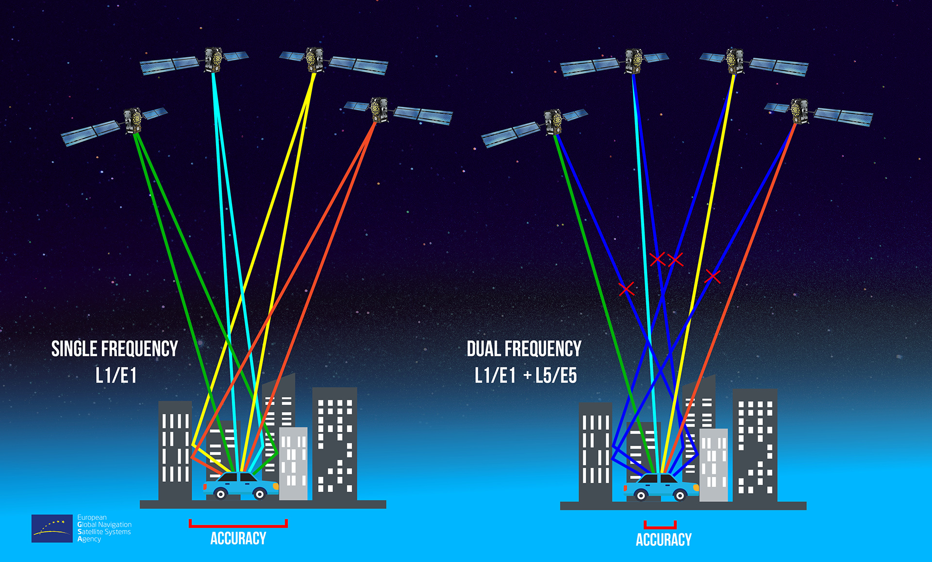
Source: GSA
“The arrival of Galileo means that numerous new possibilities have become available,” says Zelle. “In pay-as-you-go motoring, for example. That means you have to know that the vehicle is underway, what route the car is taking and how many kilometres it has covered. That has to be recorded using a receiver in the vehicle. An important aspect is that interference in the signals has to be counteracted so that the kilometres recorded are genuinely reliable.”
Autonomous driving is also very much on the rise. Requirements must be developed for these systems that will be imposed on them before they are actually allowed on the roads. NLR has already sketched this out for manned aviation in the aerospace sector and it looks destined for a key role in autonomous driving as well.
When the regulations are then developed and implemented, a verification step will be needed: testing how well the systems work, whether they meet the requirements imposed upon them, and whether the systems will continue to comply with market developments. “The focus is shifting from governmental authorities to market use,” says Zelle, “and there are some really attractive opportunities there.”
If you would like to know more about satellite navigation and how Royal NLR can assist you with it,
visit our website or contact: